Posts

Showing posts from September, 2021

Remote Sensing Software Download / ERDAS EMAGINE

  ERDAS EMAGINE with Crack

Definition of Human Geography / What Is ‘Human Geography’?

Image
Definition of Human Geography The study of the patterns and dynamics of human activity on the landscape. Broadly conceived, human geography includes both those areas of geographic study that are more narrowly focused on human activity, and those that are particularly concerned with human-environment dynamics, or the nature–society tradition (W. Moseley et al., 2007) ‘That part of the discipline of geography concerned with the spatial differentiation and organization of human activity and its interrelationships with the physical environment’ (R. J. Johnston et al., 2000). Human geography is concerned with the distribution and networks of people and cultures on Earth’s surface.  A human geographer might investigate the local, regional, and global impact of rising economic powers China and India, which represent 37 percent of the world’s people. They also might look at how consumers in China and India adjust to new technology and markets, and how markets respond to such a huge consumer ba

The Process and Elements of Remote Sensing

Image
In much of remote sensing,  the process  involves an interaction between incident radiation and the targets of interest. This is exemplified by the use of imaging systems where the following seven elements are involved. Note, however that remote sensing also involves the sensing of emitted energy and the use of non-imaging sensors.   1. Energy Source or Illumination (A)  - the first requirement for remote sensing is to have an energy source which illuminates or provides electromagnetic energy to the target of interest. 2. Radiation and the Atmosphere (B)  - as the energy travels from its source to the target, it will come in contact with and interact with the atmosphere it passes through. This interaction may take place a second time as the energy travels from the target to the sensor. 3. Interaction with the Target (C)  - once the energy makes its way to the target through the atmosphere, it interacts with the target depending on the properties of both the target and the radiation

Definition of Remote Sensing/What is Remote Sensing

Image
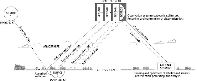
Definition of remote sensing Remote sensing is the  science of obtaining information  about objects or areas from a distance, typically from aircraft or satellites. Remote sensing  is the science of obtaining the physical properties of an area without being there.It allows users to capture, visualize, and analyze objects and features on the Earth’s surface. Remote that means something which is not exactly in contact or physical contact, Sensing means getting information, data something like temperature, pressure, photograph, etc. Remote sensing is the process of acquiring information, detecting, analyzing, monitoring the physical characteristics of an area by recording it is reflected and emitted radiation energy without having any physical contact with the object under study. This is done by capturing the reflected radiation/energy. "Remote sensing is the science (and to some extent, art) of acquiring information about the Earth's surface without actually being in contact w

GIS Mapping / Four (4) Main Ideas of GIS Mapping

Image
GIS Mapping GIS mapping produces visualizations of geospatial information. The 4 main ideas of Geographic Information Systems (GIS) are: Creating GIS data or geographic data Database Creation and management of geo-spatial data Analysis of GIS data Presentation or visualization of analyzed data Because viewing and analyzing data on maps impacts our understanding of data, we can make better decisions using GIS. It helps us understand  what  is  where . The analysis becomes simple. Answers become clear. Source: https://gisgeography.com/

Basic Questions Related to GIS / Common Terminology of GIS

Image
  Terminology/Basic Questions  Related To GIS What is GIS Shapefile & Grids Vector & Raster DEM & TIN Coordinate Systems Classification of Coordinate Systems Other File Formats Raster or Vector ? DEM or TIN ? Other Basic Questions 1.1. GIS GIS      A  geographic   information   system  (GIS),  also  known  as  a geographical  information   system, is an information  system  for capturing, storing, analyzing, managing and presenting data  which are spatially referenced (linked to location) 1.2.Shape file & Grids Coverage   : In geographic  information  systems, a coverage  is a mapping of  one  aspect  of  data   in  space.  It  represents  a  "domain"  (the  universe  of extent)  in  terms  of   characteristics  expressing  a  range  of  values.  Aerial photography,   land  cover  data,  and   digital  elevation  models  are  all considered  coverage  data. Below are two types of coverage   which are used in GIS for representation of informat

What is GIS or Geographic Information System

Image
Definition of GIS/ What is GIS Definition of GIS can be summed up as follows:  GIS stands for Geographic Information Systems and is a computer-based tool that examines spatial relationships, patterns, and trends in geography. Geographic Information Systems (GIS) store, analyze, and visualize data for geographic positions on Earth’s surface. Geographical Information System (GIS) is a computer based information system used to digitally represent and analyze the geographic features present on the Earth’s surface and the events that taking place on it. Geographic Information Systems provide a method for integrating and analyzing spatial (digital map based) information such as "where is the nearest Hospital?" Alongside related non-spatial information (what services are given there?). Many people are becoming far more familiar with seeing the results both textually - for example when their phone shows them the nearest Hotel - and on open map systems such as Google Maps. Geographic

Factors in Soil Formation

Image
Factors in Soil Formation 1.       Climate : The two most important climatic variables influencing soil formation are temperature and moisture.   ·          Temperature   has a direct influence on the   weathering   of bedrock to produce mineral particles. Rates of bedrock weathering generally increase with higher temperatures. Temperature also influences the activity of soil microorganisms, the frequency and magnitude of soil chemical reactions, and the rate of plant growth. ·          Moisture levels in most soils are primarily controlled by the addition of water via   precipitation   minus the losses due to evapotranspiration . High moisture availability in a soil promotes the weathering of bedrock and sediments, chemical reactions, and plant growth. The availability of moisture also has an influence on soil   pH   and the decomposition   of   organic matter . 2.        Topography : This refers to the landscape position and the slopes it has. Steep, long slopes mean water

Geologic Time

Image
Geologic Time Geologists and geomorphologists describe the Earth's geologic history through a temporal system known as the  geologic time scale  . On this scale, time is measured using the following four units of time:  eons ,  eras ,  periods  and  epochs . All of these temporal subdivisions are established on the occurrence of some important geologic event. For example,  Hadean Eon  represents the time on Earth when life did not exist. During the  Archean Eon  life started and was dominated by one-celled  prokaryotic  life forms.  Eukaryotic  one-celled organisms became dominant in the  Proterozoic Eon . Multicellular organisms ruled the planet during the eon known as the  Phanerozoic . Table describes some of the important geologic events that have occurred since the Earth's formation some 4.6 billion years ago.   Table:  Geologic time scale.   Eon   Era   Period