Posts

Showing posts with the label Geography

How to Prepare Campus Map or Any Institutional Location Map using ArcGIS and with a little help of Graphics
Image
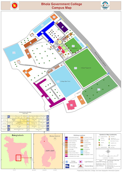
Locator map using ArcMap Creating a campus map or institutional location map using ArcGIS, coupled with graphic design elements, can significantly enhance the overall navigational experience for users. ArcGIS, a powerful geographic information system (GIS) software, allows for the integration of spatial data, making it an ideal tool for mapping diverse campus features. Begin the process by gathering relevant spatial data, such as building outlines, walkways, parking lots, and landmarks. This information can be collected through satellite imagery or surveyed using GPS devices. Import the data into ArcGIS, ensuring accurate georeferencing for precise spatial representation. Utilize the software's layering capabilities to organize the various elements of the campus map. Separate layers for buildings, roads, green spaces, and other features enable easy customization and updating. ArcGIS offers a range of symbology options, allowing users to choose distinct colors, symbols, and labels f

How to Prepare Campus Map or Any Institutional Location Map using ArcGIS and with a little help of Graphics

Image
  Locator map of Bhola Govt. College Suddenly, My boss asked me to Prepare a campus map. At first, I thought it was easy but not that much. This is not the final file. If you want to know and get the guidelines then contact with me. Oh !! It took surprisingly less time than expected. ই ক্যাম্পাস ম্যাপ বা প্রতিষ্ঠানের অবস্থান ম্যাপ তৈরি করা ArcGIS ব্যবহার করে, যা গ্রাফিক ডিজাইন উপাদানের সাথে যোগ করে তবে ব্যবহারকারীদের জন্য সামগ্রিক নেভিগেশনাল অভিজ্ঞতা অত্যন্ত উন্নত করতে পারে। একটি শক্তিশালী ভৌগোলিক তথ্য সিস্টেম (GIS) সফটওয়্যার, ArcGIS স্থানীয় তথ্যের সংযোজনের অনুমতি দেয়, এটি বিভিন্ন ক্যাম্পাস বৈশিষ্ট্যগুলি ম্যাপ করার জন্য একটি আদর্শ সরঞ্জাম। Begin the process by gathering relevant spatial data, such as building outlines, walkways, parking lots, and landmarks. This information can be collected through satellite imagery or surveyed using GPS devices. Import the data into ArcGIS, ensuring accurate georeferencing for precise spatial representation. এই প্রক্রিয়া শুরু করুন যার মাধ্যমে বিভি

Download and walkthrought of QGIS: A Free and Open Source Geographic Information System

QGIS (Quantum Geographic Information System) is free, open-source software that allows users to create, edit, visualize, analyze, and publish geospatial information. There are many benefits to using QGIS. First, the software offers many free online resources and maps available to download. <!-- Google Tag Manager (noscript) --> <noscript><iframe src="https://www.googletagmanager.com/ns.html?id=GTM-MDFS8XP" height="0" width="0" style="display:none;visibility:hidden"></iframe></noscript> <!-- End Google Tag Manager (noscript) --> QGIS is A Free and Open Source Geographic Information System. In comparison to ArcGIS, QGIS is much faster than ArcGIS. Reliability: ArcGIS has better spatial topological analytical capabilities and provides more reliable results. The value of cluster tolerance in ArcMap is limited to 0.0000009. The process of making maps using QGIS Download and install QGIS . Download Link: QGI

Google Earth Pro download full

Image
Google Earth pro pro provides sattelite imagery. click the following link to download it. Google Earth Pro  https://1drv.ms/u/s!AjlTfEQ58j61gQFGR2d4ERpYEp8f?e=1Jlq8h

Perihelion and Aphelion

Image
Perihelion and Aphelion According to Kepler's first law of planetary motion, all planets, comets, and asteroids in the Solar System have approximately elliptical orbits around the Sun. Hence, an orbiting body has a closest and a farthest point from its parent object, that is, a perihelion and an aphelion, known collectively as apsides. Orbital eccentricity measures the flatness (departure from a perfect circle) of the orbit. Perihelion The word "perihelion" stems from the Ancient Greek words "peri", meaning "near", and "helios", meaning "the Sun". The perihelion is the point in the orbit of a planet, minor planet, or comet, where it is nearest to its orbital focus, generally a star.   Aphelion "Aphelion" derives from the preposition "apo", meaning "away, off, apart". (The similar words "perigee" and "apogee" refer to the nearest and furthest points in some object's orbit around t

Earth's Size and Shape

Image
  Earth's Size The size of Earth, like the size of all of the celestial bodies, is measured in a number of parameters including mass, volume, density; surface area, mean diameter, and circumference . Earth's Shape Earth's circumference and diameter differ because its shape is classified as an oblate spheroid or ellipsoid, instead of a true sphere. This means that instead of being of equal circumference in all areas, the poles are squished, resulting in a bulge at the equator, and thus a larger circumference and diameter there. The equatorial bulge at Earth's equator is measured at 26.5 miles (42.72 km) and is caused by the planet's rotation and gravity. Gravity itself causes planets and other celestial bodies to contract and form a sphere. This is because it pulls all the mass of an object as close to the center of gravity (the Earth's core in this case) as possible. Because Earth rotates, this sphere is distorted by the centrifugal force. This is the fo

Definition of Demography

Image
There are various definitions for Demography from various perspective and point of view. It is part of Human Geography and can be defined as:- According to the Oxford Dictionary Demography is  the study of statistics such as births, deaths, income, or the incidence of disease, which illustrate the changing structure of human populations. According to the Webster Dictionary Demography is the statistical study of human populations especially with reference to size and density , distribution, and vital statistics. Again Cambridge Dictionary has defined demography the study of changes in the number of births, marriages, deaths, etc. in a particular area during a period of time. So, Demography  is the study of the size, composition and distribution of human population across space and the process through which  populations change. ** ‘ Big three’ phenomenon of demography  are : Births Deaths and  Migration   These three factors are jointly producing population stability or change. Demogr

Man Environment Relationship

Man Environment relationship Man Environment Relationship