Posts

Showing posts with the label Transport Development

E-book: "The Geography of Transport Systems"

E-book: "The Geography of Transport Systems" by Jean-Paul Rodrigue with Claude Comtois and Brian Slack Click Following link to download this e-book: The Geography of Transport Systems Source: http://www.regscience.hu

Article on "Historical Transportation Development" - William L. Garrison

Historical Transportation Development  - William L. Garrison  Click following link to  download: Historical Transportation Development by William L. Garrison Courtesy: Garrison, W.L., 2003.  Historical transportation development .

Factors affecting transport system

Image
In the reconstruction of a region or a nation, transport systems invariably play a vital role. The growth and development of transportation provides a medium, contributing to the progress of agriculture, industry, commerce, administration, defense, education, health or any other community activity. Many of the regional characteristics that are influencing the layout of the existing transformational system are the creation of their antecedent transformational features. The present-day transport network has evolved out of the past framework because as trail evolves successfully into the pioneer dirt road, then into the improved farm road and finally, into the present day paved highways with heavy motor traffic. Many factors are involved in the development of a transport system. The present-day transport system of a country or a region cannot be explained by one factor alone. In fact, services of interrelated factors are responsible for the development of transport system as depi

A Case Study of the Spatial Pattern of Road Transport in Ghaggar Plain

Image
Following content has been collected from:  http://www.geographynotes.com The Ghaggar plain is a micro-geo-historic region of India covering Ganganagar and Hanumangarh districts of the Rajasthan State, as identified by R.L. Singh (1971) and C.D. Deshpande (1982). River Ghaggar is known as a ‘dead river’ and at present it is simply in the form of dry bed, flooded during rains. An important characteristic feature of this region is that it was humid in very ancient period, became arid afterwards and with the availability of canal water converted as an agricul­tural region, not only of the state but of India. Among various means of transportation, road transport plays a vital role in the transformation of the regional economy of the region. Spatial Pattern: The simple distribution pattern of road transportation as shown in Figure 4.12 indicates that although all the tehsils are well served by roads, yet Suratgarh, Anupgarh, Nohar and Ganganagar tehsils are having 12.9, 11.2,11.1,

Taaffe, Morrill and Gould (TMG) Model

Image
Taaffe, Morrill and Gould, in 1963, undertook a comparative analysis of the development of transport in developing countries and they were able to show that certain broad regularities permitted “a descriptive generalization of an ideal typical sequence of transportation development”. Their spatial model of transport network development in developing countries has proved to be a valuable help in the understanding of transport development and has been widely applied. The model which Taaffe and his colleagues devised was based upon Ghanaian and Nigerian experience, but it has been found to be applicable to other developing lands, for example, in Latin America. TMG Model Taaffe et al. identified six stages in their sequence of transportation development. Figure 3.3 illustrates the sequential stages in the evolution of the transport network. The first stage consists of scattered settlements and small ports along a coast, which arose from colonial occupation. Such coastal se

Gould’s Spatial Exploration Model of Transport Development

Image
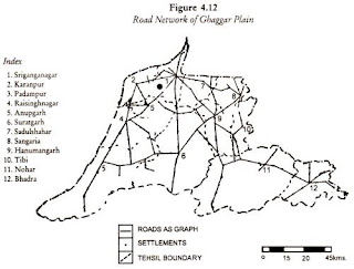
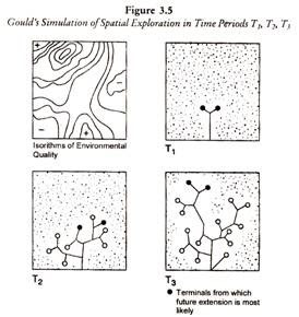
The behavioural model was proposed in 1966 as an alternative to the Taaffe, Morrill and Gould concepts of transport development. It incorporates a random approach and is based upon a simulation of search theory, with the development of a transport network within an area, which contains resources and hazards, or constraints, indicated by isorithms of environmental quality. The developer aims to tap the resources of a previously unexploited area, depicted as a square, by building roads from a port on the coast, which forms one side of this square. As road building proceeds so the developer will encounter the resources and the constraints, such as mountains or rivers, within the environment. In stage one capital is invested in roads, which diverge from the port in straight lines. In stage two, information on the nature of the resources or of the hazards encountered by the advancing roads is fed back to the development who may react in one of two ways. The resource already tappe

The Vance Model of Transport Development

Image
Based on his work on the eastern seaboard of America, Vance (1970) developed a five-stage ‘mercantile’ model to illustrate the development of transport links and the growth of the urban hierarchy in North America (Figure 3.6). Although primarily concerned with trade, his model is important in that it stresses the impact of exogenous forces on the evolution of transport networks and their associated spatial patterns. The Vance Model of Transport Development In the initial stage, an accumulating of wealth in Europe prompted overseas expansion of an exploratory nature. Stage 2 sees the beginnings of the transatlantic trade routes based on the one-way trade in staple products such a fish, furs and timber. From 1620, permanent settlement occurs in North America; this results in Atlantic trade in both directions as settlers begin to produce commodities for export and consume manufactured products from a rapidly industrialising Europe (stage 3). Internal transport links are limited

The Rimmer Model of Transport Development

Image
An alternative and complementary perspective is provided by Rimmer (1977) who outlined the development of a hybrid transport system in less-developed countries, derived from the colonization process by which metropolitan powers used revolutionary modes ot transport to penetrate indigenous systems and to gain both political control and cultural and economic dominance. The resultant restructuring of resource use, patterns of circulation, organization and outlook transformed the indigenous system, and instituted an interdependen relationship in which the colonizing power to a substantial extent controlled a two-way exchange of goods and services. This process eventually yielded a hybrid transport system in developing countries containing both indigenous and imported elements, often inadequately integrated. Using terminology derived from Brookfield (1972, 1975), Rimmer identified four phases in the evolving interrelationships between metropolitan and Third World co