Posts

Showing posts with the label Remote Sensing

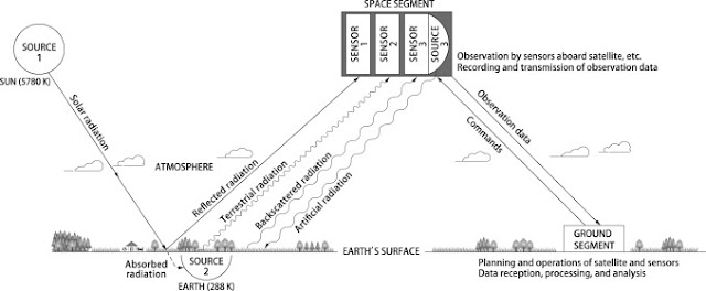
How to Prepare Campus Map or Any Institutional Location Map using ArcGIS and with a little help of Graphics

Image
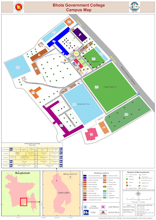
  Locator map of Bhola Govt. College Suddenly, My boss asked me to Prepare a campus map. At first, I thought it was easy but not that much. This is not the final file. If you want to know and get the guidelines then contact with me. Oh !! It took surprisingly less time than expected. ই ক্যাম্পাস ম্যাপ বা প্রতিষ্ঠানের অবস্থান ম্যাপ তৈরি করা ArcGIS ব্যবহার করে, যা গ্রাফিক ডিজাইন উপাদানের সাথে যোগ করে তবে ব্যবহারকারীদের জন্য সামগ্রিক নেভিগেশনাল অভিজ্ঞতা অত্যন্ত উন্নত করতে পারে। একটি শক্তিশালী ভৌগোলিক তথ্য সিস্টেম (GIS) সফটওয়্যার, ArcGIS স্থানীয় তথ্যের সংযোজনের অনুমতি দেয়, এটি বিভিন্ন ক্যাম্পাস বৈশিষ্ট্যগুলি ম্যাপ করার জন্য একটি আদর্শ সরঞ্জাম। Begin the process by gathering relevant spatial data, such as building outlines, walkways, parking lots, and landmarks. This information can be collected through satellite imagery or surveyed using GPS devices. Import the data into ArcGIS, ensuring accurate georeferencing for precise spatial representation. এই প্রক্রিয়া শুরু করুন যার মাধ্যমে বিভি

Google Earth Pro download full

Image
Google Earth pro pro provides sattelite imagery. click the following link to download it. Google Earth Pro  https://1drv.ms/u/s!AjlTfEQ58j61gQFGR2d4ERpYEp8f?e=1Jlq8h

The Process and Elements of Remote Sensing

Image
In much of remote sensing,  the process  involves an interaction between incident radiation and the targets of interest. This is exemplified by the use of imaging systems where the following seven elements are involved. Note, however that remote sensing also involves the sensing of emitted energy and the use of non-imaging sensors.   1. Energy Source or Illumination (A)  - the first requirement for remote sensing is to have an energy source which illuminates or provides electromagnetic energy to the target of interest. 2. Radiation and the Atmosphere (B)  - as the energy travels from its source to the target, it will come in contact with and interact with the atmosphere it passes through. This interaction may take place a second time as the energy travels from the target to the sensor. 3. Interaction with the Target (C)  - once the energy makes its way to the target through the atmosphere, it interacts with the target depending on the properties of both the target and the radiation

Definition of Remote Sensing/What is Remote Sensing

Image
Definition of remote sensing Remote sensing is the  science of obtaining information  about objects or areas from a distance, typically from aircraft or satellites. Remote sensing  is the science of obtaining the physical properties of an area without being there.It allows users to capture, visualize, and analyze objects and features on the Earth’s surface. Remote that means something which is not exactly in contact or physical contact, Sensing means getting information, data something like temperature, pressure, photograph, etc. Remote sensing is the process of acquiring information, detecting, analyzing, monitoring the physical characteristics of an area by recording it is reflected and emitted radiation energy without having any physical contact with the object under study. This is done by capturing the reflected radiation/energy. "Remote sensing is the science (and to some extent, art) of acquiring information about the Earth's surface without actually being in contact w

What is GIS or Geographic Information System

Image
Definition of GIS/ What is GIS Definition of GIS can be summed up as follows:  GIS stands for Geographic Information Systems and is a computer-based tool that examines spatial relationships, patterns, and trends in geography. Geographic Information Systems (GIS) store, analyze, and visualize data for geographic positions on Earth’s surface. Geographical Information System (GIS) is a computer based information system used to digitally represent and analyze the geographic features present on the Earth’s surface and the events that taking place on it. Geographic Information Systems provide a method for integrating and analyzing spatial (digital map based) information such as "where is the nearest Hospital?" Alongside related non-spatial information (what services are given there?). Many people are becoming far more familiar with seeing the results both textually - for example when their phone shows them the nearest Hotel - and on open map systems such as Google Maps. Geographic