A Case Study of the Spatial Pattern of Road Transport in Ghaggar Plain
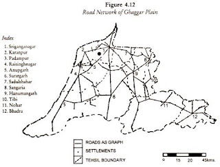
Following content has been collected from: http://www.geographynotes.com The Ghaggar plain is a micro-geo-historic region of India covering Ganganagar and Hanumangarh districts of the Rajasthan State, as identified by R.L. Singh (1971) and C.D. Deshpande (1982). River Ghaggar is known as a ‘dead river’ and at present it is simply in the form of dry bed, flooded during rains. An important characteristic feature of this region is that it was humid in very ancient period, became arid afterwards and with the availability of canal water converted as an agricultural region, not only of the state but of India. Among various means of transportation, road transport plays a vital role in the transformation of the regional economy of the region. Spatial Pattern: The simple distribution pattern of road transportation as shown in Figure 4.12 indicates that although all the tehsils are well served by roads, yet Suratgarh, Anupgarh, Nohar and Ganganagar tehsils are having 12.9, 11.2,11...