How to Prepare Campus Map or Any Institutional Location Map using ArcGIS and with a little help of Graphics
 |
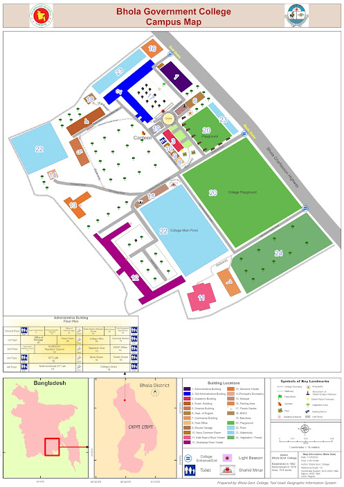
| Locator map of Bhola Govt. College |
ই ক্যাম্পাস ম্যাপ বা প্রতিষ্ঠানের অবস্থান ম্যাপ তৈরি করা ArcGIS ব্যবহার করে, যা গ্রাফিক ডিজাইন উপাদানের সাথে যোগ করে তবে ব্যবহারকারীদের জন্য সামগ্রিক নেভিগেশনাল অভিজ্ঞতা অত্যন্ত উন্নত করতে পারে। একটি শক্তিশালী ভৌগোলিক তথ্য সিস্টেম (GIS) সফটওয়্যার, ArcGIS স্থানীয় তথ্যের সংযোজনের অনুমতি দেয়, এটি বিভিন্ন ক্যাম্পাস বৈশিষ্ট্যগুলি ম্যাপ করার জন্য একটি আদর্শ সরঞ্জাম।
Begin the process by gathering relevant spatial data, such as building outlines, walkways, parking lots, and landmarks. This information can be collected through satellite imagery or surveyed using GPS devices. Import the data into ArcGIS, ensuring accurate georeferencing for precise spatial representation.
এই প্রক্রিয়া শুরু করুন যার মাধ্যমে বিভিন্ন ক্যাম্পাস বৈশিষ্ট্যগুলির মধ্যে যেমন ভবনের বাহ্যিক, পথ, পার্কিং জোন এবং স্থলমার্ক ইত্যাদি সহজেই জোড়া যেতে পারে তাদের সংগ্রহ করে। এই তথ্যটি স্যাটেলাইট ইমেজ বা GPS ডিভাইস ব্যবহার করে একত্র করা যেতে পারে। ArcGIS এ তথ্যটি আমদানি করুন, নির্দিষ্ট স্থানিক প্রতিনিধিত্বের জন্য সঠিক জিওরেফারেন্সিং নিশ্চিত করুন।
Utilize the software's layering capabilities to organize the various elements of the campus map. Separate layers for buildings, roads, green spaces, and other features enable easy customization and updating. ArcGIS offers a range of symbology options, allowing users to choose distinct colors, symbols, and labels for each map component, enhancing visual clarity.
সফটওয়্যারের লেয়ারিং সুবিধাগুলি ব্যবহার করুন ক্যাম্পাস ম্যাপের বিভিন্ন উপাদানগুলি সংগঠন করতে। ভবন, রাস্তা, সবুজ অঞ্চল এবং অন্যান্য বৈশিষ্ট্যগুলির জন্য পৃষ্ঠভূমি ছাড়া করুন এবং সহজেই কাস্টমাইজেশন এবং আপডেটিং সম্ভাবনা করে। ArcGIS এ বিভিন্ন সাইম্বোলজি বিকল্পগুলি প্রদান করে, যা ব্যবহারকারীদেরকে প্রতিটি ম্যাপ উপাদানের জন্য বিশেষ রঙ, প্রতীক এবং লেবেল চয়ন করতে দেয়, দৃষ্টি স্পষ্টতা বাড়াতে।

Comments
Post a Comment