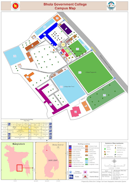
Creating a campus map or institutional location map using ArcGIS, coupled with graphic design elements, can significantly enhance the overall navigational experience for users. ArcGIS, a powerful geographic information system (GIS) software, allows for the integration of spatial data, making it an ideal tool for mapping diverse campus features.
Begin the process by gathering relevant spatial data, such as building outlines, walkways, parking lots, and landmarks. This information can be collected through satellite imagery or surveyed using GPS devices. Import the data into ArcGIS, ensuring accurate georeferencing for precise spatial representation.
Utilize the software's layering capabilities to organize the various elements of the campus map. Separate layers for buildings, roads, green spaces, and other features enable easy customization and updating. ArcGIS offers a range of symbology options, allowing users to choose distinct colors, symbols, and labels for each map component, enhancing visual clarity.
To enhance the aesthetics of the map, incorporate graphic design elements. Use a graphics software tool, such as Adobe Illustrator or Photoshop, to refine the map's appearance. Add a legend, scale bar, and compass rose to provide users with essential reference points. Employ consistent fonts and colors for a professional and cohesive look.
Consider including 3D elements for prominent buildings or landmarks, providing users with a more immersive experience. This can be achieved by integrating ArcGIS's 3D mapping capabilities and enhancing them further with graphic design tools.
Regularly update the map to reflect changes in the campus layout, ensuring accuracy and reliability. Share the final map digitally on the institution's website or through mobile applications for easy access by students, staff, and visitors.
So, combining ArcGIS's robust GIS capabilities with graphic design elements results in a visually appealing and functional campus map. This integrated approach not only aids navigation but also contributes to a positive user experience within the institutional environment. If you still have difficulty then let me know so that i can provide some guidelines.


Comments
Post a Comment