Posts

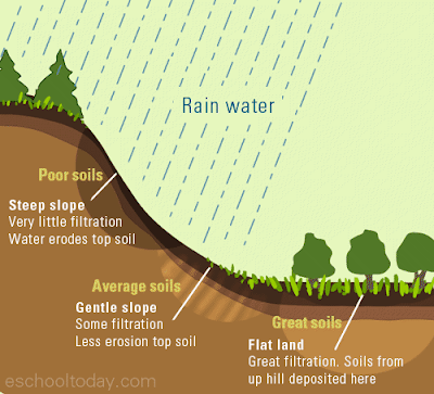
What is GIS or Geographic Information System

Image
Definition of GIS/ What is GIS Definition of GIS can be summed up as follows:  GIS stands for Geographic Information Systems and is a computer-based tool that examines spatial relationships, patterns, and trends in geography. Geographic Information Systems (GIS) store, analyze, and visualize data for geographic positions on Earth’s surface. Geographical Information System (GIS) is a computer based information system used to digitally represent and analyze the geographic features present on the Earth’s surface and the events that taking place on it. Geographic Information Systems provide a method for integrating and analyzing spatial (digital map based) information such as "where is the nearest Hospital?" Alongside related non-spatial information (what services are given there?). Many people are becoming far more familiar with seeing the results both textually - for example when their phone shows them the nearest Hotel - and on open map systems such as Google Maps. Geographic

Factors in Soil Formation

Image
Factors in Soil Formation 1.       Climate : The two most important climatic variables influencing soil formation are temperature and moisture.   ·          Temperature   has a direct influence on the   weathering   of bedrock to produce mineral particles. Rates of bedrock weathering generally increase with higher temperatures. Temperature also influences the activity of soil microorganisms, the frequency and magnitude of soil chemical reactions, and the rate of plant growth. ·          Moisture levels in most soils are primarily controlled by the addition of water via   precipitation   minus the losses due to evapotranspiration . High moisture availability in a soil promotes the weathering of bedrock and sediments, chemical reactions, and plant growth. The availability of moisture also has an influence on soil   pH   and the decomposition   of   organic matter . 2.        Topography : This refers to the landscape position and the slopes it has. Steep, long slopes mean water

Geologic Time

Image
Geologic Time Geologists and geomorphologists describe the Earth's geologic history through a temporal system known as the  geologic time scale  . On this scale, time is measured using the following four units of time:  eons ,  eras ,  periods  and  epochs . All of these temporal subdivisions are established on the occurrence of some important geologic event. For example,  Hadean Eon  represents the time on Earth when life did not exist. During the  Archean Eon  life started and was dominated by one-celled  prokaryotic  life forms.  Eukaryotic  one-celled organisms became dominant in the  Proterozoic Eon . Multicellular organisms ruled the planet during the eon known as the  Phanerozoic . Table describes some of the important geologic events that have occurred since the Earth's formation some 4.6 billion years ago.   Table:  Geologic time scale.   Eon   Era   Period

Perihelion and Aphelion

Image
Perihelion and Aphelion According to Kepler's first law of planetary motion, all planets, comets, and asteroids in the Solar System have approximately elliptical orbits around the Sun. Hence, an orbiting body has a closest and a farthest point from its parent object, that is, a perihelion and an aphelion, known collectively as apsides. Orbital eccentricity measures the flatness (departure from a perfect circle) of the orbit. Perihelion The word "perihelion" stems from the Ancient Greek words "peri", meaning "near", and "helios", meaning "the Sun". The perihelion is the point in the orbit of a planet, minor planet, or comet, where it is nearest to its orbital focus, generally a star.   Aphelion "Aphelion" derives from the preposition "apo", meaning "away, off, apart". (The similar words "perigee" and "apogee" refer to the nearest and furthest points in some object's orbit around t

Earth's Size and Shape

Image
  Earth's Size The size of Earth, like the size of all of the celestial bodies, is measured in a number of parameters including mass, volume, density; surface area, mean diameter, and circumference . Earth's Shape Earth's circumference and diameter differ because its shape is classified as an oblate spheroid or ellipsoid, instead of a true sphere. This means that instead of being of equal circumference in all areas, the poles are squished, resulting in a bulge at the equator, and thus a larger circumference and diameter there. The equatorial bulge at Earth's equator is measured at 26.5 miles (42.72 km) and is caused by the planet's rotation and gravity. Gravity itself causes planets and other celestial bodies to contract and form a sphere. This is because it pulls all the mass of an object as close to the center of gravity (the Earth's core in this case) as possible. Because Earth rotates, this sphere is distorted by the centrifugal force. This is the fo

ArcGIS 10.7 Desktop full crack download

Image
How to install ArcGIS 10.7? ArcGIS desktop 10.7 installation activation Go to the link and download from one drive. It also contains crack. Download Link:  Arc GIS 10.7 After downloading the software, follow the installation steps from the following  link how to install arcgis 10.6 / Arc GIS 10.7

ArcGis Tutorial

Image
Go to the link and download from one drive. It also contains guidelines and GIS data to getting started.  Download Link: GIS Tutorial , GIS DATA FOR PRACTICE